The Precision of the Artilleryman
A landscape is rarely just scenery to a man trained in the science of ballistics. For John Caldwell Tidball, the terrain was a series of coordinates, elevations, and obstacles. Born near Wheeling, Virginia, in 1825, his early years on an Ohio farm provided a foundation of discipline that would later define his visual output. He entered the United States Military Academy at West Point, graduating in the class of 1848. This education instilled a rigorous approach to observation. When he moved through the Seminole Wars and later served during the American Civil War, his eyes were trained to see the structural truth of the earth.
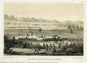
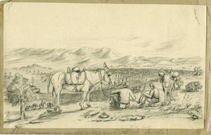
The smoke of the battlefield often obscured the view, yet Tidball’s true artistic identity emerged in the quiet, methodical work of the Pacific Railroad Surveys between 1863 and 1869. Tasked with charting routes through Nevada and Utah, he functioned as both a soldier and a surveyor. He did not seek to romanticize the American West. Instead, he used watercolor to document geological formations, vegetation, and topography with scientific fidelity. His brushwork mirrored his artillery training: precise, intentional, and focused on the factual reality of the landscape.
The Cartographer’s Eye
The work produced during these arduous expeditions serves as a visual record of an expanding nation. Tidball’s drawings captured the grit of the frontier. He rendered the subtle tonal variations of desert light and the specific textures of flora, such as his botanical studies of cacti like Cercus giganteus. These were not mere sketches; they were scholarly investigations. The portability of watercolor allowed him to work amidst the challenging terrain of the West, translating rugged mountains and arid basins into detailed records for the U.S. Geological Survey.
His technical approach relied on a commitment to realism. While other artists might have focused on the drama of the frontier, Tidball prioritized the accuracy required by railroad planners and policymakers. His ability to convey depth and scale through careful observation provided the essential data needed for infrastructure development. This period of his life represents a convergence of military duty and scientific illustration, where the act of drawing was inseparable from the act of mapping.
A Legacy of Observation
Beyond the survey maps, Tidball’s life followed the trajectory of a high-ranking officer. He rose to the rank of Brevet Major General, serving in significant campaigns from the First Battle of Bull Run through the Siege of Petersburg. His military career even led him to serve as the Commander of the Department of Alaska, acting as the military governor of the region. Even in these administrative and command roles, the habit of meticulous documentation remained.
The historical significance of his work lies in its utility. The drawings he produced helped shape the American understanding of the West during the Reconstruction era. He left behind a body of work that bridges the gap between military topography and fine art, providing a window into the physical reality of the 19th-century American landscape through the lens of a man who understood exactly how much every inch of ground mattered.
Ερωτήσεις και Απαντήσεις
Με τι άλλα ονόματα είναι γνωστός/η ο/η John Caldwell Tidball;
Ο/Η John Caldwell Tidball αναγνωρίζεται και με τα εναλλακτικά ονόματα Lt. J. C. Tidball.
Από πού προέρχεται ο/η John Caldwell Tidball;
Ο/Η John Caldwell Tidball γεννήθηκε στην/στη United States of America.